Today, August 16th is the 4 year anniversary of this blog.
Today, August 16th is the 4 year anniversary of this blog.
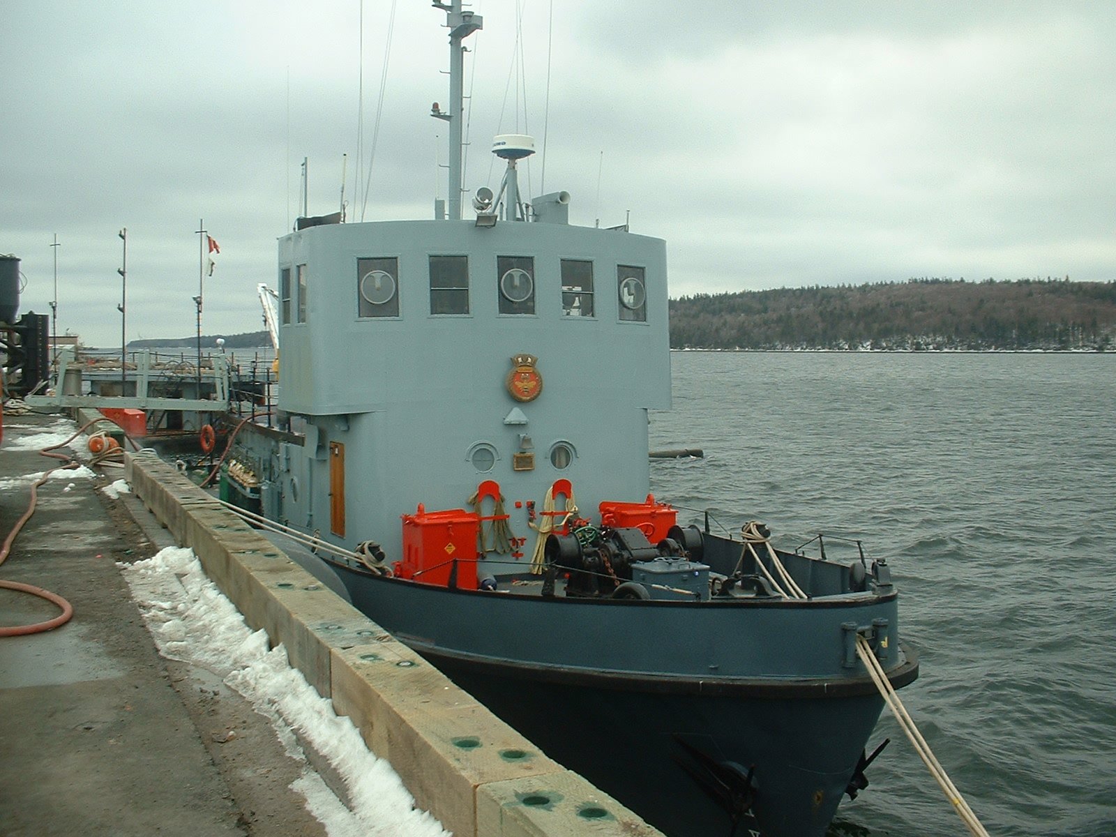 DND issued a tender to dispose of, through Ship Breaking, three auxiliary vessels YDG-2 a Deperming Barge, YRG-60 a Fueling Barge and YDT 12 Granby, which serves as Diving Tender with the Fleet Diving Unit. The winning bidder will have 45 days to remove the vessels from the Dockyard, and 1 year to complete disposal.
YDG 2 – is a Deperming Barge used for Degausing ships. YRG 60 is a Fueling Barge – used to bunker vessels within the dockyard. Granby includes significant diving facilities, including decompression chamber, so while old, its disposal is a bit surprising (the larger CFAV SECHELT YDT-610 is still in service)
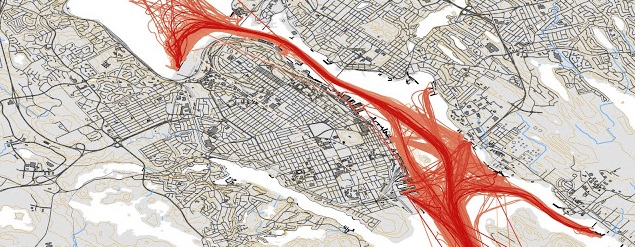
Recently I tweeted a map of 1 month of Halifax traffic from November 2011, and commented its due for an update. The latest data i have is from August 2016, so i Set out to Make the updated map. While Doing it, I also decided to Document how i did it.
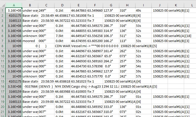
the first thing to do is grab the Log files from ShipPlotter. in my case the default location of C:\COAA\Shipplotter\logs was used. Below is a small Excerpt from one of the Logs. A Days data is about 15mb of Raw txt.
316004240;under way ;249°'; 0.1kt;44.647605N;63.549313W;288.3°;316°;56s; 150801 000000;serial#1(B)[1]
999999999;unknown ;000°'; 0.0kt;44.654905N;63.576475W; 0.0°;241°;55s; 150801 000001;serial#1(A)[1]
316015715;unknown ;000°'; 0.0kt;44.660408N;63.585980W; 70.8°;317°;57s; 150801 000002;serial#1(B)[18]
316009640;under way ;127°'; 0.1kt;44.647850N;63.549675W;121.4°;314°;58s; 150801 000003;serial#1(A)[3]
316012656;moored ;000°'; 0.0kt;44.680828N;63.610840W; 52.3°;225°;58s; 150801 000003;serial#1(A)[3]
004101175;Base station 2016-07-30;23:58:59;44.658570N;63.581072W;fix 1; 150801 000004;serial#1(A)[4]
003160159;Base station 2016-07-30;23:58:59;44.683988N;63.610005W;fix 7; 150801 000005;serial#1(A)[4]
003160115;Base station 2016-07-30;23:58:59;44.507222N;63.523333W;fix 7; 150801 000005;serial#1(A)[4]
316022239;under way ;000°'; 0.0kt;44.646912N;63.569125W;258.7°;255°;01s; 150801 000006;serial#1(A)[1]
316002800;under way ;000°'; 0.0kt;44.648033N;63.549392W;349.0°;136°;03s; 150801 000007;serial#1(A)[1]
316031831;unknown ;000°'; 0.0kt;44.675977N;63.611325W;304.1°;105°;04s; 150801 000008;serial#1(A)[1]
316009640;under way ;127°'; 0.1kt;44.647853N;63.549675W;121.4°;314°;04s; 150801 000009;serial#1(A)[3]
316014180;under way ;000°'; 0.0kt;44.654475N;63.562032W;249.2°;154°;05s; 150801 000009;serial#1(A)[1]
316013960;under way ;000°'; 0.1kt;44.632167N;63.565667W;324.0°;073°;02s; 150801 000009;serial#1(A)[1]
999999999;unknown ;000°'; 0.0kt;44.654905N;63.576473W; 0.0°;241°;04s; 150801 000010;serial#1(B)[1]
316004240;under way ;248°'; 0.2kt;44.647602N;63.549310W;296.5°;316°;06s; 150801 000010;serial#1(A)[1]
316009640;under way ;129°'; 0.1kt;44.647850N;63.549675W;121.4°;313°;06s; 150801 000011;serial#1(B)[3]
316022239;under way ;000°'; 0.1kt;44.646912N;63.569123W;256.5°;255°;10s; 150801 000014;serial#1(B)[1]
316006196;unknown ;000°'; 2.4kt;44.647903N;63.567170W;334.0°;511°;09s; 150801 000014;serial#1(B)[18]
004101175;Base station 2016-07-30;23:59:09;44.658567N;63.581068W;fix 1; 150801 000014;serial#1(B)[4]
I choose the month of august, as it was the most recent full month i had. in the folder with all the .log files, run a simple copy command to combine them all into one big file. Due to the Size, I combined 6 days of data into one file.
Copy *.log bigfile.txt
once combined, i use excel to grab the entries with a navigation status of “Under Way” I considered also collecting moored vessels, however just the underway vessels produced over 4 million lines of data in total. Once the csv file is open in Excel, I text to columned it, splitting on the semi colon. I then sort by by the Navigation status, and deleted all rows above and Below under way.
then i removed the excess columns, and saved back the csv.
after doing this with all 6 files, i combined them into one.
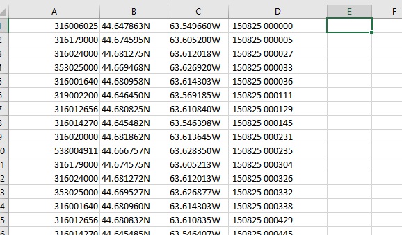
I then used notepad ++ to do a sanity check on my data – remove weirdness, and clean up the excess trialing comas. Once the underway data is collected, I combined the 5 files, and then added a Header row, to identify the MSMI, Lat, Long and the date. I am making this data available, and you can download it here: http://halifaxshippingnews.ca/AugPoints.csv (.csv 115mb) the data includes Lat/Long, Date/time and ships MMSI.
Once we have the points file, then we can move on to mapping it. – which didn’t work. oops. Need to get rid of the N, and W directional, and update to -63 to specify a west direction.
For this map, I grabbed QGIS – which is free, and created a layer from the XY Data. You basically get a Point Cloud.
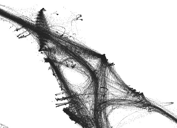 from there I ran the Points to Path tool, Which gave converted all the points to lines. I Set the layer to draw the lines really fine line weight, which gives the transparent look.
 i also did some cleanup on the lines, deleting the tracks that had long straight lines crossing land.
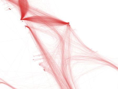
The final Map used watercourse data from GeoNova,then the image was exported from QGIS. I then manually cleaned it up in Photoshop, removing the excess watercourses leaving only the shoreline. this is also where the labels and title block were added.
I should note the 2011 map was made in ArcMap. ESRI has made getting trial licenses a pain (And i have run out of email addresses) hence me turning to QGIS.
 My timing was off, and the Atlantic Sun cleared the bridge bound for Fairview Cove while I waited for the light to change on North…
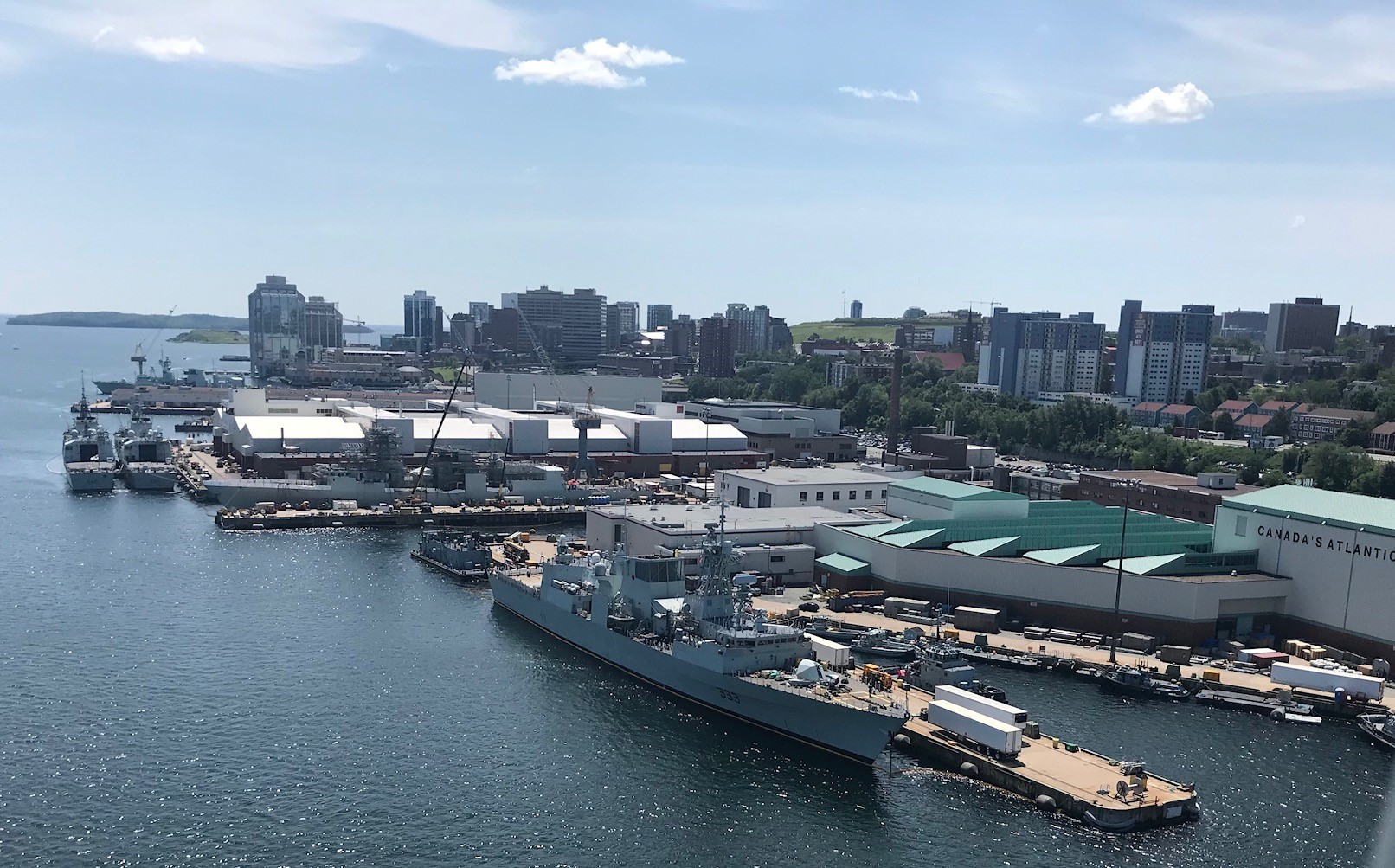
SO the Dockyard. In the foreground HMCS Toronto. Behind her is HMCS Montreal undergoing a work period. Tied up 2 abreast, HMCS St Johns and HMCS Halifax
the Bridge is a great spot for photos – As seen below.

 If you have 15 minutes, give a listen to the latest episode of the Podcast 99Percent Invisible. It Talks about BBC Radio’s Shipping Forecast, and how its become a cultural phenomena in Britain. The Podcast discusses the origins of Marine weather forecasting, and the efforts made by Admiral Robert FitzRoy, who commanded HMS Beagle on Darwin’s trip to the Galapagos, to predict the weather.
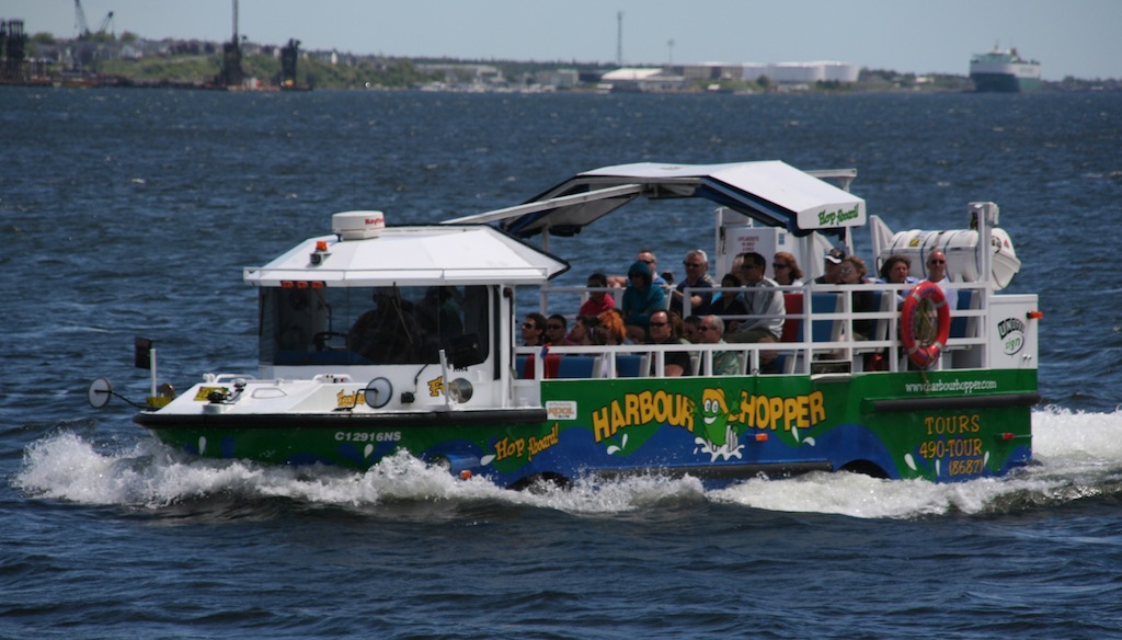
On Thursday, a Duck Boat, capsized and sank on a lake in Branson Missouri. 17 are dead, and of the 12 people who survived, 7 are in serious or critical condition. Questions are being asked about the safety of these craft, and given Murphy’s Ambassatours operates several, its worth a look. There have been several incidents involving amphibious vehicles in the last 20 years – in 1999, another DUKW sunk in Arkansas, killing 13. Closer to Home, the Lady Duck Sunk in the Ottawa River, killing 4 in 2002.
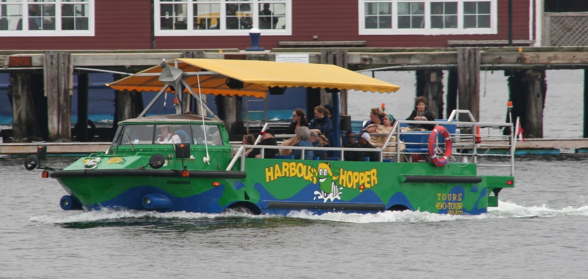
The DUKWs involved in the Arkansas and Branson Incidents are actually a modern replica of a World War II design. Ottawa’s Lady Duck was a modified Ford Pickup. Halifax’s Harbour hoppers are military surplus Vietnam Era LARC’s, so there are significant differences in terms of the vehicles involved, however a review of the Investigation reports into these incidents reveals similarities.
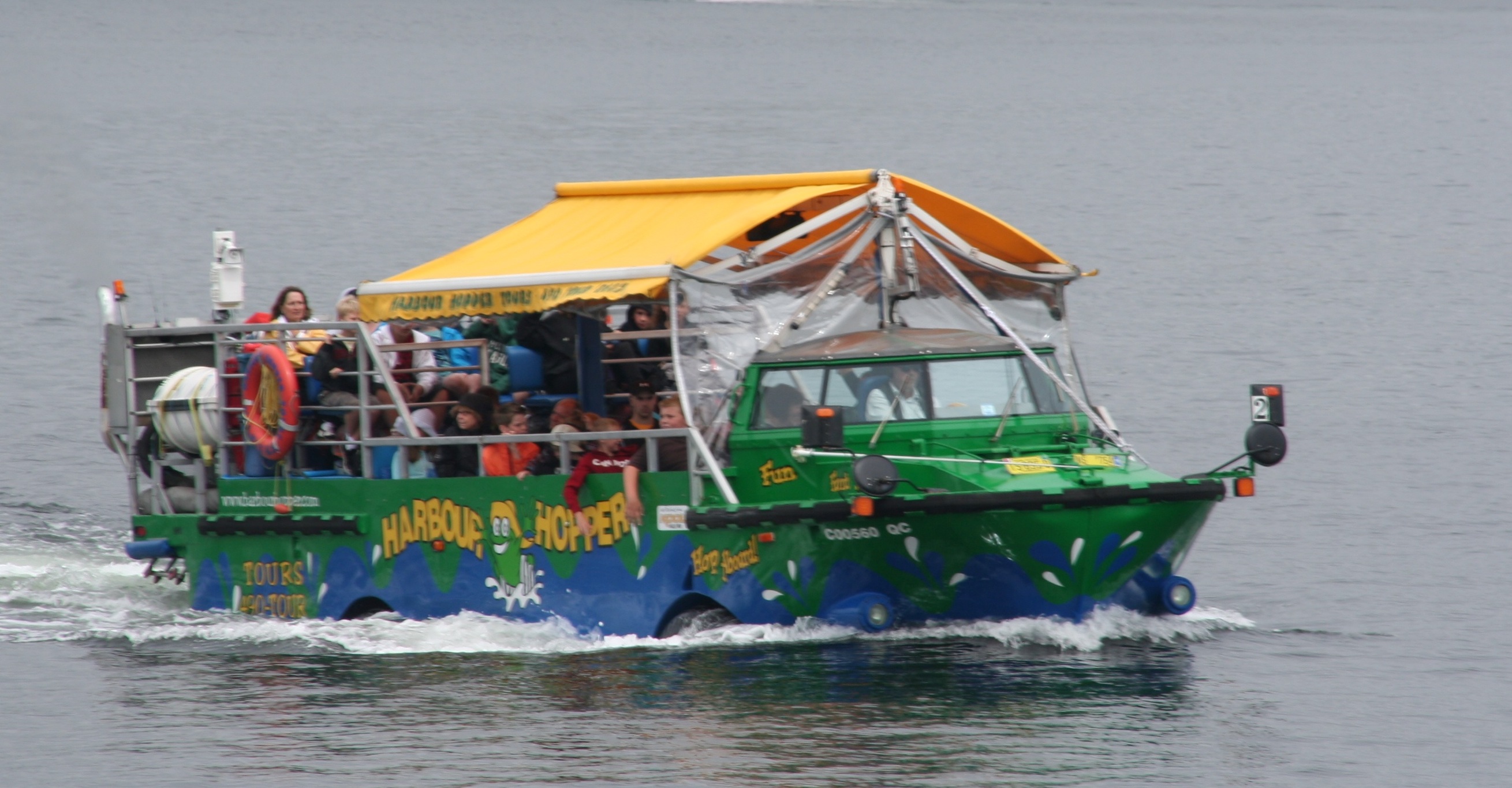 A Transportation Safety Board report into the sinking of the Lady Duck revealed that the vehicle was registered as a motor vehicle only, and not as a small vessel, thus it fell into a regulatory vacuum, and was not in compliance with marine regulations. Additionally, Small vessel regulations were very different in 2002 then they are today. Harbour Hoppers are regulated as Both a Bus (by the province), and as a Vessel (by Transport Canada) and are registered as vessels.
The TSB Report into the 2002 sinking of the Lady Duck, echoed some of the recommendations from the NTSB’s report into the Arkansas sinking, and actually included a portion of the report as an appendix. Specifically both the TSB and the NTSB recommended requiring the vessels posses enough reserve buoyancy to stay upright and afloat when flooded, and to remove canopies, or use canopies that will not restrict horizontal or vertical escape by passengers. Additionally, both reports cited a lack of maintenance to the vehicles, specifically surrounding pumps required to remove water from the vessel.
The main cause of death in both the Arkansas and Lady Duck incidents was people getting trapped by the canopy, and being unable to escape. Photos of the Stricken Duck boat from Branson seem to show that the passenger area was fully enclosed on top and on the sides. the Harbour Hoppers use a awning, which is open on the sides. as well as they are registered vessels they must meet construction and stability regulations.
I have also been informed that the Hoppers are pulled from the water the moment the wind gusts reach 22 knots / 41 km/hr. That’s a hard cutoff that both the company and Halifax Traffic (the MCTS center that controls ship traffic in the harbour) enforce strictly.
The Hoppers are also required by Transport Canada to stay within 150 meters from shore. This is mostly to keep them out of the way of the larger commercial traffic, but it doubles as a safety net where the Hoppers are never more than 30 seconds from a floating dock.
 Witness reports indicate that waves on the lake in Branson were hitting 6′ in height at the time of the incident, due to a fast approaching thunderstorm. Ultimately the report into this incident will likely sight Weather and the decision to sail, the enclosed canopy, and a failure of regulators to implement recommendations from the 1999 Arkansas incident as the causes.
these videos have been around for a few years – they were produced for AV-OG-TIL, a Norwegian NGO working to reduce the harmful effects of alcohol. They aim to raise awareness of the dangers of Impaired boating.
How to dock like a Boss
How to Launch like a Boss
Look Whos Docking Now.