Busy Day #1 – Atlantic Sun

After attempting this shot, on her westbound leg, but failing, I succeeded on the eastbound leg. Atlantic Sun is a G4 class of container and RO-RO ship for ACL, and went into service late last year.

On Arrival She took the Western birth at Fairview Cove, behind the Berlin Bridge. the K-line Vessel was due to sail at 11:30, but as of 1pm, was still at the dock.

Busy Day # 2 – Dalian Express

following closely behind Atlantic Sun, was Hapag-Llyod’s  Dalian Express. A frequent caller over the years, the ship went to the basin on arrival. Built in 2001 as Hamburg Express, She was renamed in 2011 to free up the name for a newer larger vessel. Shes Rated at 7502TEU

the Tug Atlantic Willow on position on the port side. Atlantic Bear took the stern.

Busy Day #3 – Three for fuel.

The bunkering tanker Algoma Dartmouth will be kept busy today with 3 vessels anchoring to top up their tanks.

First up is the Norwegian flagged, geared bulker, NordKap. She arrived from Brazil, and will likely sail for the St Lawrence, likely with a load of Bauxite for aluminum production. She is Due to Sail at 15:00. (She Sailed giving Port Alfred PQ as her destination – Home to Rio-Tinto Alcan)

Due at the Pilot station at 1500 is the Liberian flagged Crude oil tanker ALMI GALAXY, which arrived from Scapa Flow Scotland and spent the last couple of days at anchor in the approaches. Shes due to anchor at anchorage #1 (between Georges Is. and McNabs Is.) laden, she was required to enter port with  a tug escort, and will be bound for the refinery in Saint John NB. on departure. She sailed at 2245.

also due for fuel is the products tanker Navig8 Sirius. the marshal islands flagged ship is arriving at the pilot station at 1600 from Houston Texas, unladen with refined product. she is Due to sail at 0200

Ill try to update this post later tonight with photos of the tankers, when they arrive.

Port Traffic

After Musing about creating an update to the One Month of Traffic map from November 2011 – last week i hinted that an update was underway. Well its done. and the final product can be seen above.

(Above) Close up of the inner Harbour.

(Above) Activity at Halifax Shipyard – Note the  tugs moving a vessel into the graving dock (Below) the ferry tracks. You can actually see the individual paths on both sides of the Gang plank.

As Promised, I also wrote a separate post about how the map was created.

Making the Map

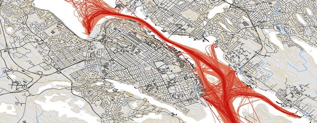
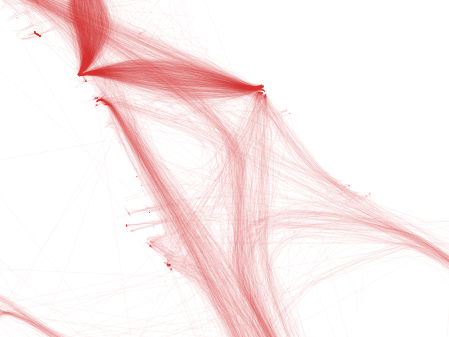
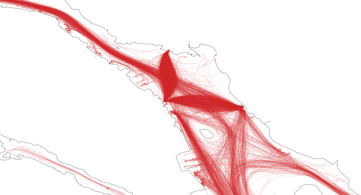
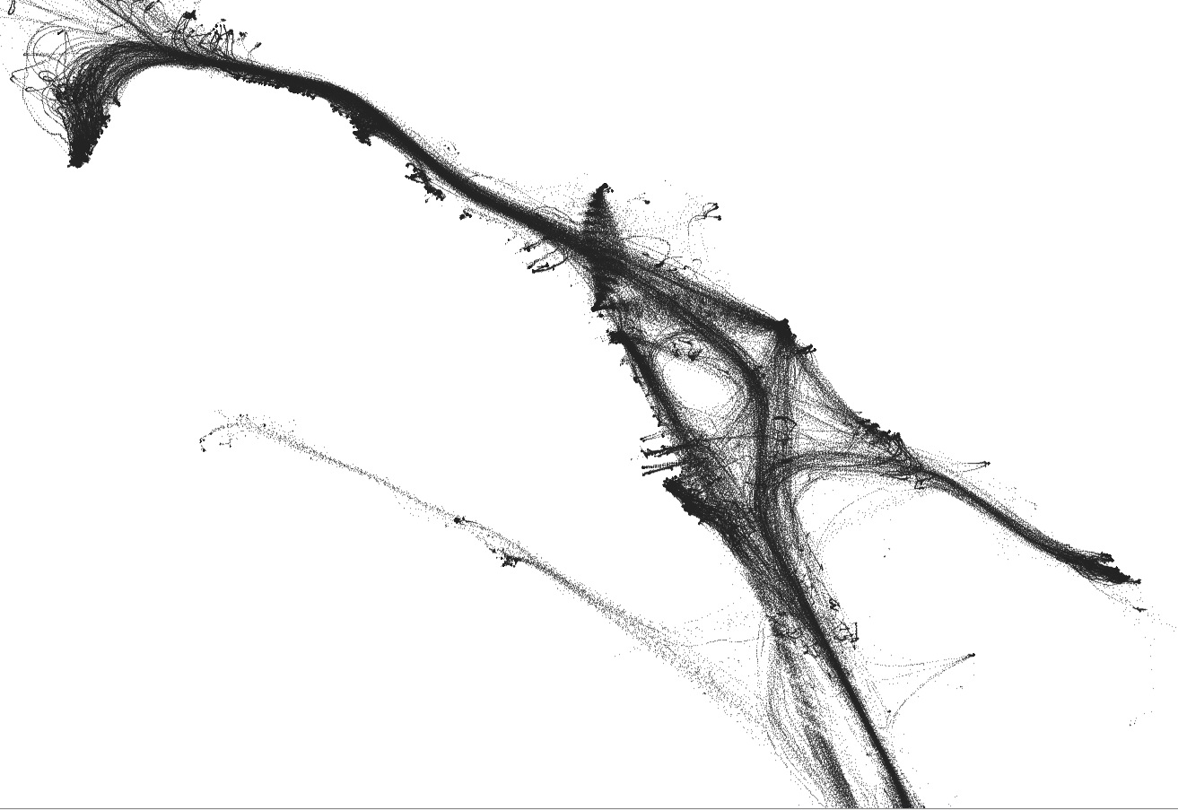
Recently I tweeted a map of 1 month of Halifax traffic from November 2011, and commented its due for an update. The latest data i have is from August 2016, so i Set out to Make the updated map. While Doing it, I also decided to Document how i did it.

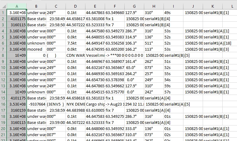
the first thing to do is grab the Log files from ShipPlotter. in my case the default location of C:\COAA\Shipplotter\logs was used. Below is a small Excerpt from one of the Logs. A Days data is about 15mb of Raw txt.

316004240;under way ;249°'; 0.1kt;44.647605N;63.549313W;288.3°;316°;56s; 150801 000000;serial#1(B)[1]
999999999;unknown ;000°'; 0.0kt;44.654905N;63.576475W; 0.0°;241°;55s; 150801 000001;serial#1(A)[1]
316015715;unknown ;000°'; 0.0kt;44.660408N;63.585980W; 70.8°;317°;57s; 150801 000002;serial#1(B)[18]
316009640;under way ;127°'; 0.1kt;44.647850N;63.549675W;121.4°;314°;58s; 150801 000003;serial#1(A)[3]
316012656;moored ;000°'; 0.0kt;44.680828N;63.610840W; 52.3°;225°;58s; 150801 000003;serial#1(A)[3]
004101175;Base station 2016-07-30;23:58:59;44.658570N;63.581072W;fix 1; 150801 000004;serial#1(A)[4]
003160159;Base station 2016-07-30;23:58:59;44.683988N;63.610005W;fix 7; 150801 000005;serial#1(A)[4]
003160115;Base station 2016-07-30;23:58:59;44.507222N;63.523333W;fix 7; 150801 000005;serial#1(A)[4]
316022239;under way ;000°'; 0.0kt;44.646912N;63.569125W;258.7°;255°;01s; 150801 000006;serial#1(A)[1]
316002800;under way ;000°'; 0.0kt;44.648033N;63.549392W;349.0°;136°;03s; 150801 000007;serial#1(A)[1]
316031831;unknown ;000°'; 0.0kt;44.675977N;63.611325W;304.1°;105°;04s; 150801 000008;serial#1(A)[1]
316009640;under way ;127°'; 0.1kt;44.647853N;63.549675W;121.4°;314°;04s; 150801 000009;serial#1(A)[3]
316014180;under way ;000°'; 0.0kt;44.654475N;63.562032W;249.2°;154°;05s; 150801 000009;serial#1(A)[1]
316013960;under way ;000°'; 0.1kt;44.632167N;63.565667W;324.0°;073°;02s; 150801 000009;serial#1(A)[1]
999999999;unknown ;000°'; 0.0kt;44.654905N;63.576473W; 0.0°;241°;04s; 150801 000010;serial#1(B)[1]
316004240;under way ;248°'; 0.2kt;44.647602N;63.549310W;296.5°;316°;06s; 150801 000010;serial#1(A)[1]
316009640;under way ;129°'; 0.1kt;44.647850N;63.549675W;121.4°;313°;06s; 150801 000011;serial#1(B)[3]
316022239;under way ;000°'; 0.1kt;44.646912N;63.569123W;256.5°;255°;10s; 150801 000014;serial#1(B)[1]
316006196;unknown ;000°'; 2.4kt;44.647903N;63.567170W;334.0°;511°;09s; 150801 000014;serial#1(B)[18]
004101175;Base station 2016-07-30;23:59:09;44.658567N;63.581068W;fix 1; 150801 000014;serial#1(B)[4]

I choose the month of august, as it was the most recent full month i had. in the folder with all the .log files, run a simple copy command to combine them all into one big file. Due to the Size, I combined 6 days of data into one file.

Copy *.log bigfile.txt

once combined, i use excel to grab the entries with a navigation status of “Under Way” I considered also collecting moored vessels, however just the underway vessels produced over 4 million lines of data in total. Once the csv file is open in Excel, I text to columned it, splitting on the semi colon. I then sort by by the Navigation status, and deleted all rows above and Below under way.

then i removed the excess columns, and saved back the csv.
after doing this with all 6 files, i combined them into one.

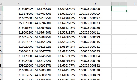
I then used notepad ++ to do a sanity check on my data – remove weirdness, and clean up the excess trialing comas. Once the underway data is collected, I combined the 5 files, and then  added a Header row, to identify the MSMI, Lat, Long and the date. I am making this data available, and you can download it here: http://halifaxshippingnews.ca/AugPoints.csv (.csv 115mb) the data includes Lat/Long, Date/time and ships MMSI.

Once we have the points file, then we can move on to mapping it. – which didn’t work.  oops. Need to get rid of the N, and W directional, and update to -63 to specify a west direction.

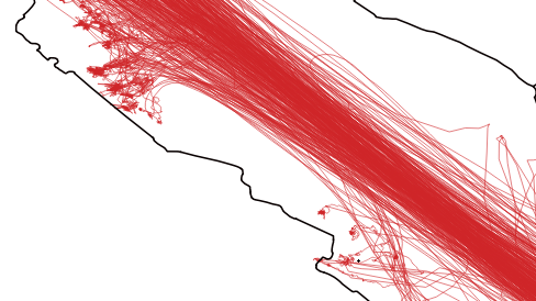
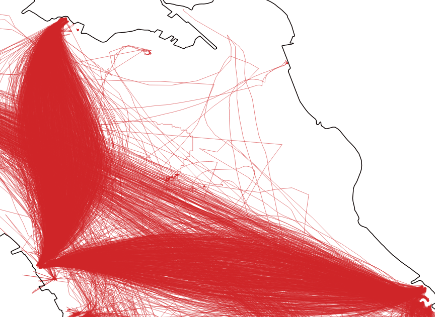
For this map, I grabbed QGIS – which is free, and created a layer from the XY Data. You basically get a Point Cloud.

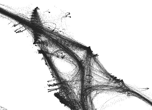
from there I ran the Points to Path tool, Which gave converted all the points to lines. I Set the layer to  draw the lines really fine line weight, which gives the transparent look.

i also did some cleanup on the lines, deleting the tracks that had long straight lines crossing land.

The final Map used watercourse data from GeoNova,then the image was exported from QGIS. I then manually cleaned it up in Photoshop, removing the excess watercourses leaving only the shoreline. this is also where the labels and title block were added.

I should note the 2011 map was made in ArcMap. ESRI has made getting trial licenses a pain (And i have run out of email addresses) hence me turning to QGIS.
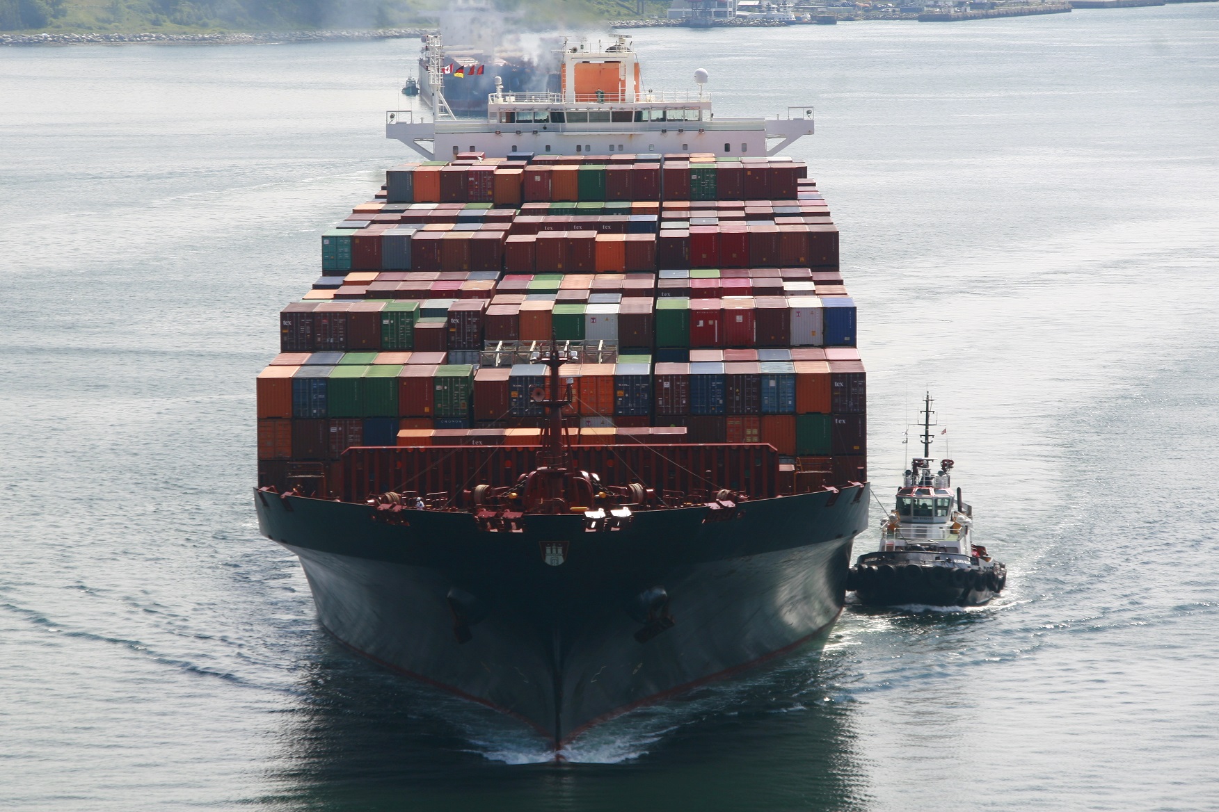
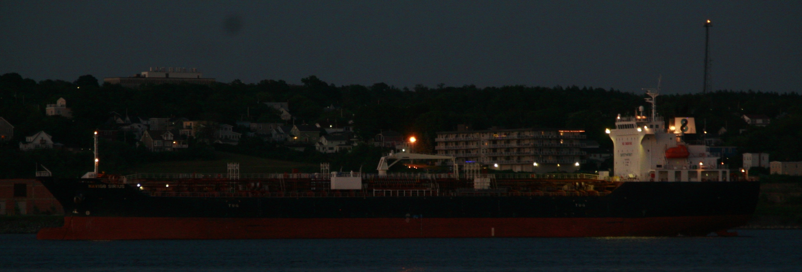
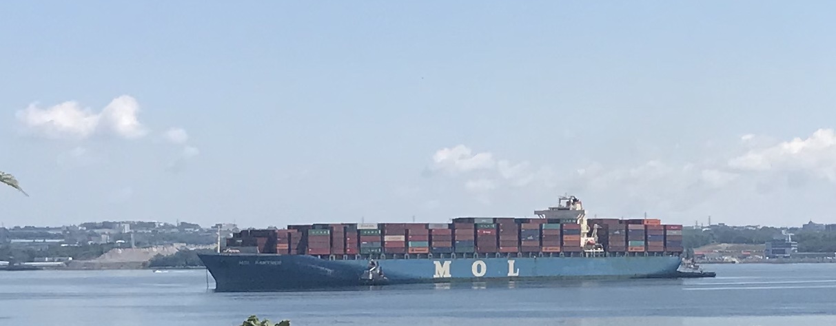
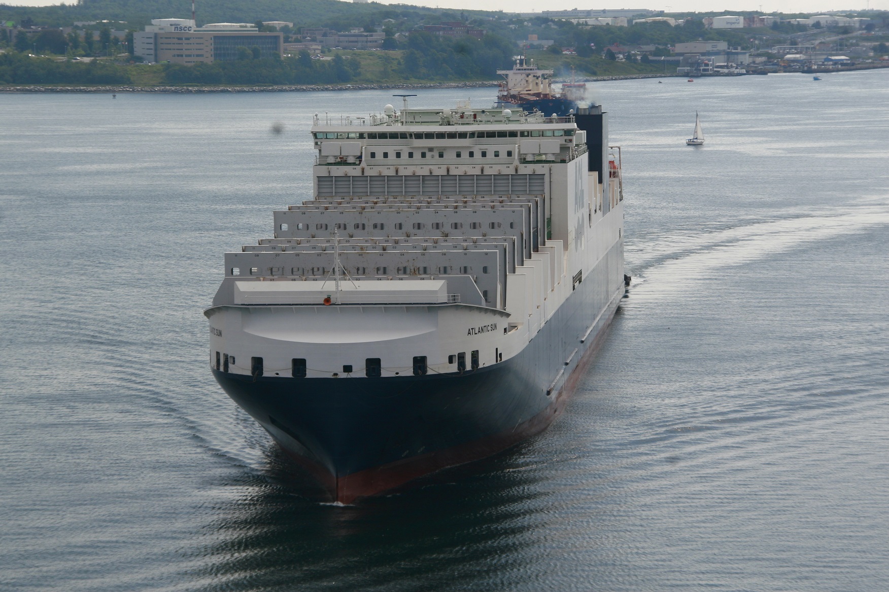
Your Camouflage Game is Weak – News #11

if you like HalifaxShippingNews.ca, consider becoming a member. 2$ a month really helps cover costs, and in return you get the site Ad Free.

For latest port conditions, Including Weather,Wind, Tides, Arrivals and Departures be sure to visit the Port Report (Members get the information in realtime, not every 2 hours)

News

1. Harbour Hoppers.
After my article about the safety of the Harbour Hoppers, Halifax Today and  the Herald ran articles on the safety of the Vehicles. Indecently the preliminary report from the NTSB has been released. U.S. Coast Guard announced that it was convening a Marine Accident Board to investigate the accident.

2.Trade War and Boats
Apparently the Trump trade war is Causing headaches for US Boatbuilders – Both driving up their input costs, and adding 25% cost to buyers. Since Canada has free trade with Europe (And a large supply of aluminum) this could be good news for domestic industry.

3.New Scallop Vessel

Comeau’s Sea Foods, based in Saulnierville NS, has ordered a new Factory Scallop fishing vessel. The ship will be built in Spain, but was designed by Bedford based Allswater Marine. It is expected to be delivered in 2020. The ship will be named Lady Comeau III after Thérèse Comeau, the wife of Comeau’s Sea Foods founder, Bernardin Comeau.

Interesting

1. GTS Katy Incident
This Twitter thread is interesting- it tells the story of the GTS Katie, a commercial ship carrying military equipment back to Canada. A dispute among the ship owners and the company hired by the military to bring our kit back, so the ship was ordered not to enter Canadian Waters by her owners.

In the End the ship was Boarded,  arrested, and escorted to a Canadian port.

2. Container Ship Cruising
JOC has a piece on a Container ship Cruise. recall you can actually sail to Vancouver from Halifax on CMA-CGM’s Columbus loop.

3. Hiding Ships
We are all familiar with dazzle schemes used in the first and Second world wars. It was meant to Disrupt the eye and make ships courses harder to determine. It was Proposed by Painter Norman Wilkinson (who painted Canada’s Answer), In part to Discredit the Cubist Movement. (How can it be art, if its Utilitarian) Clever – but then I came across this Tweet

after which, I was sent the image below of a Swedish warship.

History

Aug 7, 1996 – After spending 26years on the bottom, the Oil Barge Irving whale is raised, and the hulk towed into Halifax. She still sails today as the deck barge Atlantic Sealion

Aug 6, 1942 – HMCS Assiniboine rams and sinks German submarine U-210 south of Greenland

Aug 3, 1492 – Christopher Columbus, working for Spain, sailed for the Orient, But found south America

Aug ,1 1798 – The battle of the Nile – The British defeat the French fleet.


Not a Holiday at Fairview Cove.

Mol Partner sits at anchor in the basin waiting for a birth to free up at Fairview Cove.

Despite today being a holiday, the ships were stacking up at Fairview cove. Sunday night brought the arrival of YM Express to the west birth. She Sailed Monday morning, and was replaced by Budapest Bridge, while the east birth was taken up by Atlantic Sea, both arriving early morning. When Budapest Bridge sailed late afternoon, MOL Partner was finally able to take up her spot Mol Partner is currently scheduled to sail just after midnight, Atlantic Sea is due to depart Tuesday afternoon, having had her ro-ro decks worked Monday, and her containers Tuesday.


One Month of Traffic – August 2016

After Musing about creating an update to the One Month of Traffic map from November 2011 – I went  back into the data archives, and found the last full month I have August 2016.

So Above is a first look at the data, without context. the 2016 map the data set was huge – 4.6 million lines in the text file – 509mb in size, 2.5 times bigger then the 2011 Map. More vessels now carry AIS – including the ferries, which you can see fanning out in the middle of the map.

As part of this Update, I also have been documenting how I built it, in detail, which will become its own post. If you want to play now, I am giving away the point data above. you can download it here: http://halifaxshippingnews.ca/AugPoints.csv (.csv 115mb) the data includes Lat/Long, Date/time and ships MMSI.

AOPS Update

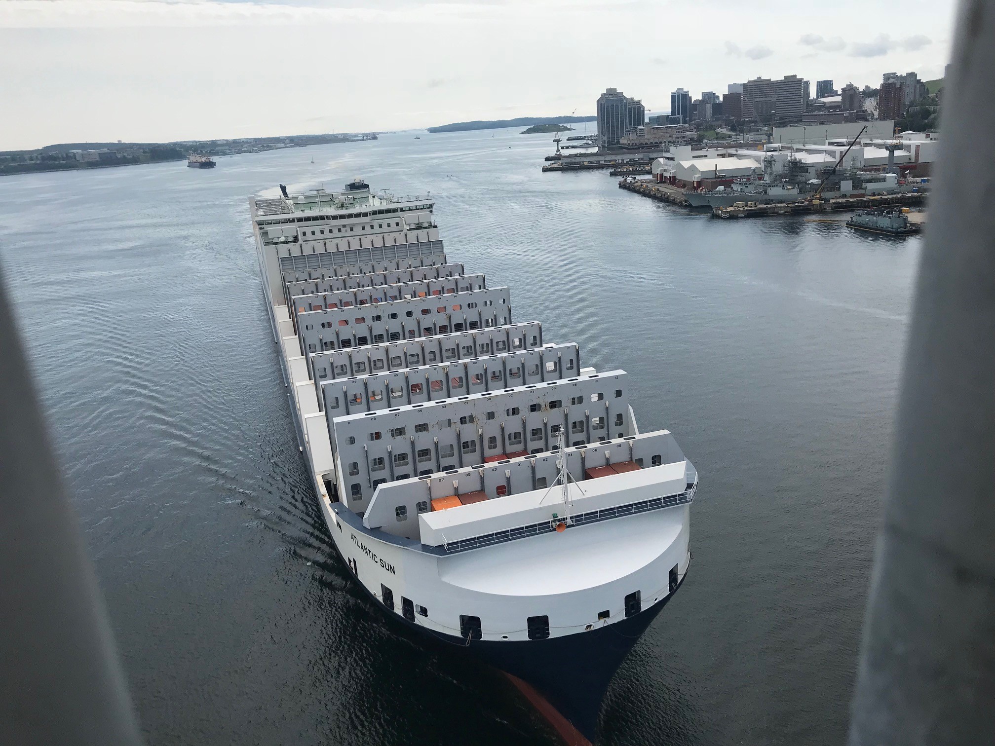
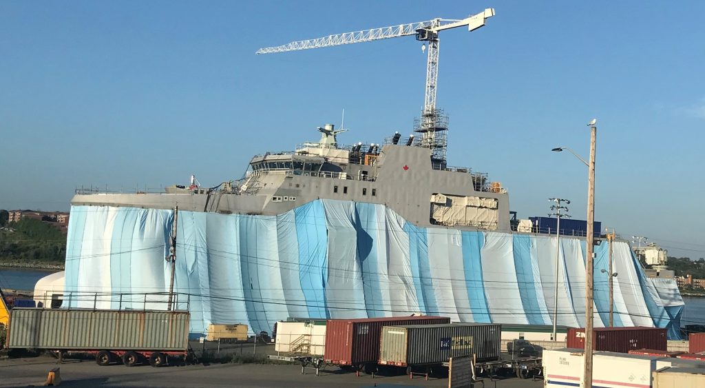
(Above) The first AOPS, the Future HMCS Harry DeWolf has been tarped off for painting, prior to launching in September. the modules were painted indoors as they were built, though it was presumably with a primer, as the grey is not the Canadian navy grey in use on existing warships.

(Below)The Middle and Stern Mega blocks for the Future HMCS Margaret Brooke are well underway. they will be moved out Post launching of the Dewolf and assembled, then joined by the Bow mega block.

Bunker C fuel spill in the Harbour @ NSP Tufts Cove Power Plant


Word is there a significant fuel spill of bunker C fuel at Tufts Cove. Sources indicate a pipe burst at the power plant leaking bunker C oil.

The Coastguard has Halifax Inshore rescue on scene. As well Connors Diving was deploying oil boom.

UPDATES Will Be Posted at https://blog.halifaxshippingnews.ca/2018/08/tuftsspill.html
as they become available below

UPDATE 21:00: ECRC D03 (Above) was on scene as part of the  cleanup. the East Coast Response Co Maintains staff and equipment to deal with oil spills at oil production and shipping facilities, and maintain equipment at the Ultramar dock in Eastern Passage.

Bunker C tends to float, and it looks like boom was deployed quickly, probably easing the cleanup in the Harbour. I would expect Transport Canada to have there red Dash-8 100 aircraft performing NASP Flights looking for additional pollution.

UPDATE 22:54
NSP Has issued a statement

NSP have also promised an update tomorrow morning

Though the Tufts Cove plant normally runs natural gas, it was originally built as an oil fired plant to replace the coal fired plant in the south end (which has now been remade into Nova Scotia Power headquarters) the plant typically tops up the bunker C from a tanker every year.

UPDATE 08/03 10:00

UPDATE 10:23
I’m getting reports of Oil on the water well south of the narrows. there also appears to be a helicopter performing an aerial survey in the area. Yesterday Evening a NotShip (Notice to Shipping) was issued requesting a Low Wake and Wide birth when passing tufts cove.

UPDATE 1045:
Photos via our friends at Haligonia (Via Twitter), from the shores of Shannon Park. Oil on shore where the tide went out, also Birds and Seals potentially effected.

UPDATE 11:49: NSP’s promised update by 11:30 is now 19 minutes late.

UPDATE 1215:

NSP Issued their Update. From the Release:

The leak was discovered in an exterior pipe that runs from the onsite storage tanks into the facility by staff during a routine inspection. Plant staff immediately activated environmental response protocols by stopping oil flow through the pipe to prevent further leakage, deploying a boom in the area of the water nearest to the leak, and alerting the company’s environmental services contractors.

Work last night and this morning included the installation of two additional booms in Halifax Harbour in front of the plant as a precaution to contain the oil. Vacuum trucks and oil absorbent materials (pom poms) are being used to remove the oil from the water surface. Additionally, workers are actively assessing the water and shoreline in the area by helicopter and by boat to prioritize areas requiring cleanup.

We still don’t know how much oil was released, or since this was apparently discovered by routine inspection – how long oil was leaking for.

Update 08/07: Cleanup continued over the long weekend, and a large area infront of the power plant is still boomed off. There are also reports of Oil on shore outside the boomed area – which is likely, as the outgoing tide would draw the oil south.  NSP reports the spill happened within 2 hours of discovery, which would have the spill occurring on the rising tide.

NSP Claims the spill was 5000L – onto Land this sounds like its under reported, given the oil still in the water, and the reports of oil not contained within the booms.

Related Posts Plugin for WordPress, Blogger...